Posts

Showing posts with the label benchmarks

Benchmarks in England

Image
Across Great Britain is a network of benchmarks.  There used to be about half a million benchmarks, but as they have become obsolete, about half have disappeared.  The first primary leveling in the UK was carried out in 1841-60, the second in 1912-21, and the third in 1951-56. The horizontal bar above the arrow denotes a calcuated and known height or altitude in relation to other Odnance Survey marks across the UK. The datum for mainland Great Britain is mean sea level at Newlyn. They were used for map making before the advent of GPS. This one is on a pillar outside the Corn Exchange building in Leeds These are in Bibury  
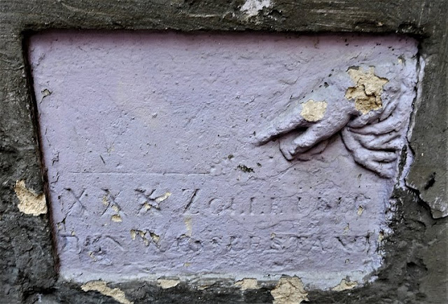
German-Language Benchmark in Lviv

Image
I came across a curious German-language benchmark in one of Lviv's courtyards. Unlike the other pre-WWI benchmarks that I have seen in Lviv, which are small simple plaques in Polish, this one is much larger, in German, and even includes a relief of a hand pointing to the leveling mark. The sign reads:  XXX Zolle über den Wasserstand  (30 Feet Above Sea Level) And while this one was from the Austrian-era (the building where it is found dates from 1911), it was not part of the first leveling system created in Lviv (1880-1888), which was used to construct Lviv's first sewer system. More on Lviv's benchmarks can be found here . Example of Polish-language benchmark from original network Z.W. = Znak Wysokosci (Height Marker)

Floodmarks in Prague

Image
Throughout the centuries many disastrous floods struck Prague. In particular, one such flood struck September 2-5, 1890. I came across a few memorial plaques which mark the level reached by the floodwaters. Výška vody  4. září 1890 Water level  4 September 1890

Benchmarks and Antique Shutters in Berehovo

Image
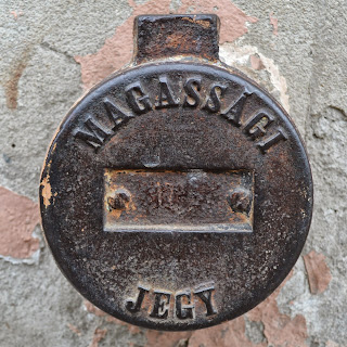
Berehovo, or "Ukrainian Hungary," is a town in Zakarpattia, located only 5 km from the Hungarian border. For most of its history it was part of Hungary, and so this heritage is still strongly visible in the cityscape (all street signs, many shop signs, etc., are in both Hungarian and Ukrainian). Today even most of the cars have Hungarian license plates. All around the center I found these large metal knobs with the words " Magassági jegy," which later I discovered means "elevation mark." These date from before WWI. More on benchmarks here .  Old wooden shutters Antique metal shutter První moravská továrna na rolety ANT. BILEK (Antonin Bilek's first moravian company for roller shutters) Interestingly, on the bottom of the shutter is an image of a lion, very similar to one that I found in Lviv (red shutter posted below). However, on the Lviv shutter no manufacturer's mark remains. In Lviv

Benchmark on Lviv's City Hall

Image
Somehow I only found out about this benchmark last week, so it wasn't included in my original post about benchmarks in Lviv . And I had walked by it thousands of times as it is located right on the Lviv's City Hall. On the benchmark is "znak wysokości (Polish for "height marker"), an eagle (Poland's coat of arms), and the letters "P. N." It's possible "P. N." stands for "Polska Norma" (Polish Standard) or "Poprawka Normalna" (Normal Adjustment). As it features the Polish coat of arms, it dates from the interwar period when Lviv was part of the Second Polish Republic. image from here

Benchmark in Przemysl

Image
I found an old benchmark in Przemysl, located on a little post near the river. The outer ring reads "Znak Wysokosci" (Height Marker), followed by 2 letters and 4 numbers, looks like AA-0001, which means it was probably the first one in the series from this period (1947-1955). The inner ring reads "Uszkodzenie Podlega Karze" (Damage Is Punishable)

Benchmarks in Lviv

Image
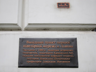
A benchmark is geographic point whose elevation has been measured and recorded to a high level of accuracy. The  height of a benchmark is calculated relative to the heights of nearby benchmarks in a network extending from a fundamental benchmark ( a point which records a height to extreme accuracy . ) Benchmarks are used by such professionals as surveyors, engineers, and map makers . In 1880-1888, the Department of Geodesy of the Lviv Polytechnic created the first leveling network in Lviv consisting of 18 benchmarks. The network was used for the construction of Lviv’s first sewer. (The Galicia state leveling network was created by the Military Geographical Institute in Vienna between 1888 and 1892.) Lviv’s fundamental benchmark was installed on the wall of the main building of the Lviv Polytechnic in 1880 by famous astronomical surveyor, rector of the Lviv Polytechnic, Professor Dominik Zbrozhek. The height was determined by barometric surveying from the level of...