Benchmarks in Lviv
A benchmark is geographic point whose
elevation has been measured and recorded to a high level of accuracy. The height of a benchmark is
calculated relative to the heights of nearby benchmarks in a network extending
from a fundamental benchmark (a
point which records a height to
extreme accuracy.) Benchmarks are used by such professionals as surveyors,
engineers, and map makers.


In 1880-1888, the
Department of Geodesy of the Lviv
Polytechnic created the first leveling network in Lviv consisting of 18
benchmarks. The network was used for the construction of Lviv’s first sewer. (The
Galicia state leveling network was created by the Military Geographical
Institute in Vienna between 1888
and 1892.)
Lviv’s fundamental
benchmark was installed on the wall of the main building of the Lviv
Polytechnic in 1880 by famous
astronomical surveyor, rector of the Lviv Polytechnic, Professor Dominik
Zbrozhek. The height was determined by barometric surveying from the level of
the Adriatic Sea with the help of a highly
skilled international commission.
Here is the first
benchmark with a plaque in honor of Dominik Zbrozhek.
 |
| "The starting point of the first leveling network in Lviv" |
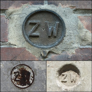
“Z. W.” stands for “znak wysokosci,” which is Polish for
“height marker.”
 |
| image from article about Dominik Zhbrozhek |
Wall marker
а – brass frustum in the wall;
б – iron plate labeled Z. W. (Znak wysokosci);
в – modern look.
а – brass frustum in the wall;
б – iron plate labeled Z. W. (Znak wysokosci);
в – modern look.
Benchmarks were often located
on churches and other public buildings. Only a handful of the original 18
benchmarks are still visible in Lviv’s landscape. The rest are either under
plaster or have been removed.
I have found two of the original benchmarks (in addition to the one on the university,) plus the place where one used to be.
 |
| on former Roman Catholic Church of St. Mary of Snow |
 |
| on Shevchenko St. |
 |
| on St. Andrew's Church |
The next batch of benchmarks (or so I am guessing, and also guessing they were installed during Austrian times) are round and also have the initials “Z. W.”
One is on the former Church of Our Lady of Perpetual Help, another on a
building that I believe was some sort of governmental building (as there is Lviv coat of arms on it), and the third one is on the old Lychakiv train
station (built in 1906, rail line has been closed for decades).

My guess is that the
third batch of benchmarks was the small circular metal ones with numbers, which are still found
on many on buildings in Lviv. I am quite certain these were also from the pre-Soviet era.

Then there are a few different kinds from the Soviet era. There generally have some sort of letters (abbreviations)
and often numbers as well.

УКР ГИИНТИЗ (UKR GIINTIZ) = Russian abbreviation for Ukrainian Geological-Engineering and Technical Surveying. (For example, a GIINTIZ institute would include the subjects geology, geodesy, geophysics.)

ПОЛИГ (POLIG) = short for “polygonometry” – method of establishing geodetic networks
ГУГК (GUGK) = the Head Office of Geodesy and Cartography
3072 = number of the marker in the registry with the geodesic description of its location


Comments
Post a Comment